| Flow (in cfs) - last revised Mar 20, 2026 | ||||||||||
|---|---|---|---|---|---|---|---|---|---|---|
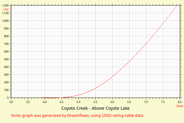
| Height (feet) | .0 | .1 | .2 | .3 | .4 | .5 | .6 | .7 | .8 | .9 |
| 3 | 0 | |||||||||
| 4 | 0 | 1 | 2 | 5 | 9 | 16 | 27 | 38 | 51 | 65 |
| 5 | 79 | 94 | 111 | 128 | 146 | 166 | 186 | 212 | 242 | 275 |
| 6 | 309 | 344 | 381 | 420 | 460 | 502 | 545 | 590 | 636 | 684 |
| 7 | 733 | 783 | 835 | 888 | 942 | 998 | 1055 | 1113 | 1172 | 1233 |
| 8 | 1295 | 1359 | 1423 | 1489 | 1556 | 1623 | 1692 | 1762 | 1833 | 1904 |
| 9 | 1977 | 2051 | 2125 | 2200 | 2277 | 2354 | 2432 | 2511 | 2591 | 2672 |
| 10 | 2753 | 2836 | 2919 | 3003 | 3088 | 3174 | 3257 | 3342 | 3427 | 3513 |
| 11 | 3600 | 3688 | 3776 | 3865 | 3954 | 4045 | 4136 | 4228 | 4320 | 4413 |
| 12 | 4507 | 4602 | 4697 | 4793 | 4889 | 4987 | 5084 | 5183 | 5282 | 5382 |
| 13 | 5483 | 5584 | 5686 | 5788 | 5891 | 5995 | 6099 | 6204 | 6310 | 6416 |
| 14 | 6523 | 6630 | 6738 | 6847 | 6956 | 7066 | 7176 | 7287 | 7399 | 7511 |
| Height (feet) | .0 | .1 | .2 | .3 | .4 | .5 | .6 | .7 | .8 | .9 |
| 15 | 7624 | 7737 | 7851 | 7965 | 8080 | 8196 | 8312 | 8429 | 8547 | 8664 |
| 16 | 8783 | 8902 | 9022 | 9142 | 9262 | 9384 | 9505 | 9628 | 9751 | 9874 |
| 17 | 9998 | 10123 | 10248 | 10373 | 10499 | 10626 | 10753 | 10881 | 11009 | 11138 |
| 18 | 11267 | 11397 | 11527 | 11658 | 11789 | 11921 | ||||