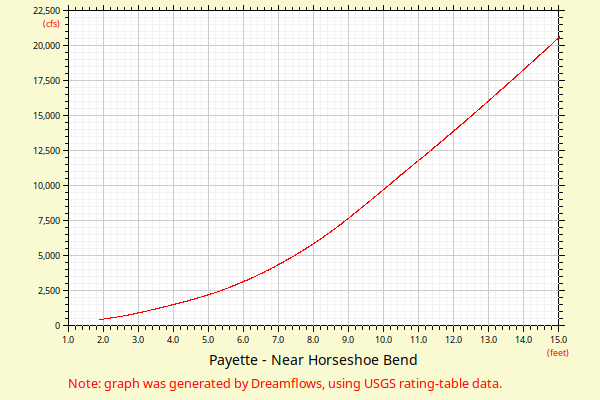
| Flow (in cfs) - last revised Dec 21, 2023 | ||||||||||
|---|---|---|---|---|---|---|---|---|---|---|
| Height (feet) | .0 | .1 | .2 | .3 | .4 | .5 | .6 | .7 | .8 | .9 |
| 1 | 500 | 535 | ||||||||
| 2 | 572 | 610 | 649 | 689 | 730 | 773 | 817 | 863 | 910 | 958 |
| 3 | 1007 | 1058 | 1110 | 1164 | 1219 | 1275 | 1333 | 1392 | 1452 | 1514 |
| 4 | 1577 | 1640 | 1706 | 1772 | 1840 | 1909 | 1980 | 2052 | 2125 | 2200 |
| 5 | 2276 | 2353 | 2432 | 2520 | 2611 | 2705 | 2801 | 2899 | 3000 | 3103 |
| 6 | 3209 | 3318 | 3430 | 3545 | 3662 | 3781 | 3904 | 4029 | 4157 | 4288 |
| 7 | 4421 | 4558 | 4697 | 4839 | 4985 | 5133 | 5284 | 5439 | 5596 | 5757 |
| 8 | 5921 | 6088 | 6258 | 6432 | 6609 | 6789 | 6973 | 7160 | 7351 | 7545 |
| 9 | 7743 | 7942 | 8142 | 8342 | 8545 | 8750 | 8955 | 9162 | 9369 | 9577 |
| 10 | 9785 | 9993 | 10202 | 10411 | 10620 | 10830 | 11040 | 11244 | 11448 | 11653 |
| 11 | 11859 | 12065 | 12272 | 12480 | 12689 | 12898 | 13108 | 13319 | 13530 | 13742 |
| 12 | 13955 | 14168 | 14382 | 14596 | 14812 | 15027 | 15244 | 15461 | 15679 | 15897 |
| Height (feet) | .0 | .1 | .2 | .3 | .4 | .5 | .6 | .7 | .8 | .9 |
| 13 | 16116 | 16335 | 16556 | 16776 | 16998 | 17219 | 17442 | 17665 | 17888 | 18113 |
| 14 | 18337 | 18563 | 18788 | 19015 | 19242 | 19469 | 19697 | 19926 | 20155 | 20384 |
| 15 | 20614 | 20845 | 21076 | 21307 | 21540 | 21772 | 22005 | 22239 | 22473 | 22708 |
| 16 | 22943 | 23178 | 23414 | 23651 | 23888 | 24126 | 24363 | 24602 | 24841 | 25080 |