| Flow (in cfs) - last revised Feb 14, 2026 | ||||||||||
|---|---|---|---|---|---|---|---|---|---|---|
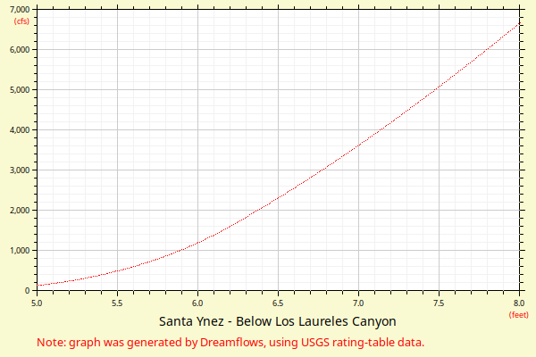
| Height (feet) | .0 | .1 | .2 | .3 | .4 | .5 | .6 | .7 | .8 | .9 |
| 3 | 0 | 0 | ||||||||
| 4 | 1 | 3 | 5 | 10 | 18 | 30 | 46 | 69 | 97 | 134 |
| 5 | 179 | 235 | 301 | 380 | 468 | 559 | 662 | 777 | 906 | 1049 |
| 6 | 1207 | 1380 | 1574 | 1776 | 1985 | 2200 | 2421 | 2647 | 2879 | 3117 |
| 7 | 3359 | 3606 | 3858 | 4114 | 4375 | 4640 | 4909 | 5182 | 5460 | 5741 |
| 8 | 6026 | 6315 | 6607 | 6903 | 7203 | 7505 | 7812 | 8121 | 8434 | 8750 |
| 9 | 9069 | 9391 | 9717 | 10045 | 10376 | 10710 | 11047 | 11387 | 11729 | 12075 |
| 10 | 12423 | 12834 | 13249 | 13667 | 14088 | 14514 | 14942 | 15374 | 15810 | 16248 |
| 11 | 16690 | 17135 | 17583 | 18035 | 18489 | 18947 | 19407 | 19871 | 20338 | 20807 |
| 12 | 21279 | 21755 | 22233 | 22714 | 23197 | 23684 | 24173 | 24665 | 25159 | 25657 |
| 13 | 26157 | 26659 | 27164 | 27672 | 28182 | 28695 | 29210 | 29728 | 30248 | 30771 |
| 14 | 31296 | 31823 | 32353 | 32885 | 33420 | 33957 | 34496 | 35038 | 35582 | 36128 |
| Height (feet) | .0 | .1 | .2 | .3 | .4 | .5 | .6 | .7 | .8 | .9 |
| 15 | 36676 | 37227 | 37780 | 38335 | 38892 | 39452 | 40013 | 40577 | 41143 | 41711 |
| 16 | 42281 | 42854 | 43428 | 44004 | 44583 | 45163 | 45746 | 46331 | 46917 | 47506 |
| 17 | 48097 | 48689 | 49284 | 49880 | ||||||