| Flow (in cfs) - last revised Sep 11, 2012 | ||||||||||
|---|---|---|---|---|---|---|---|---|---|---|
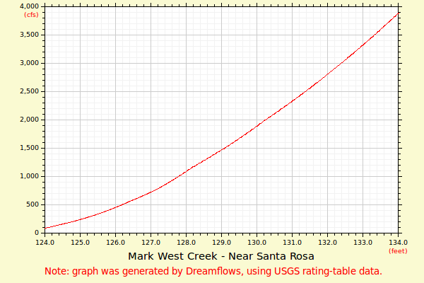
| Height (feet) | .0 | .1 | .2 | .3 | .4 | .5 | .6 | .7 | .8 | .9 |
| 122 | 1 | 1 | 1 | 2 | 3 | 4 | 6 | 10 | ||
| 123 | 15 | 20 | 25 | 32 | 38 | 46 | 55 | 65 | 77 | 88 |
| 124 | 100 | 113 | 127 | 142 | 158 | 172 | 187 | 202 | 218 | 234 |
| 125 | 252 | 270 | 289 | 308 | 328 | 349 | 371 | 394 | 417 | 441 |
| 126 | 465 | 491 | 518 | 545 | 572 | 598 | 624 | 650 | 678 | 706 |
| 127 | 735 | 764 | 796 | 831 | 867 | 904 | 941 | 980 | 1020 | 1060 |
| 128 | 1100 | 1140 | 1180 | 1220 | 1250 | 1290 | 1330 | 1360 | 1400 | 1440 |
| 129 | 1480 | 1520 | 1560 | 1600 | 1640 | 1690 | 1730 | 1770 | 1810 | 1860 |
| 130 | 1900 | 1950 | 1990 | 2040 | 2080 | 2120 | 2160 | 2210 | 2250 | 2300 |
| 131 | 2340 | 2390 | 2430 | 2480 | 2530 | 2570 | 2620 | 2670 | 2720 | 2770 |
| 132 | 2820 | 2870 | 2920 | 2970 | 3020 | 3070 | 3120 | 3170 | 3230 | 3280 |
| 133 | 3330 | 3390 | 3440 | 3500 | 3550 | 3610 | 3660 | 3720 | 3780 | 3830 |
| Height (feet) | .0 | .1 | .2 | .3 | .4 | .5 | .6 | .7 | .8 | .9 |
| 134 | 3890 | 3950 | 4010 | 4070 | 4130 | 4190 | 4250 | |||