| Flow (in cfs) - last revised May 16, 2023 | ||||||||||
|---|---|---|---|---|---|---|---|---|---|---|
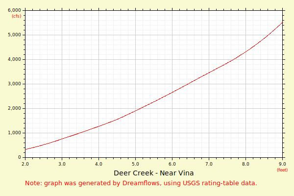
| Height (feet) | .0 | .1 | .2 | .3 | .4 | .5 | .6 | .7 | .8 | .9 |
| 0 | 55 | 68 | 82 | |||||||
| 1 | 98 | 116 | 135 | 156 | 178 | 202 | 228 | 256 | 285 | 316 |
| 2 | 349 | 384 | 420 | 458 | 498 | 540 | 584 | 630 | 678 | 727 |
| 3 | 779 | 828 | 877 | 926 | 977 | 1027 | 1079 | 1131 | 1184 | 1237 |
| 4 | 1291 | 1346 | 1401 | 1457 | 1514 | 1573 | 1642 | 1711 | 1781 | 1852 |
| 5 | 1923 | 1996 | 2069 | 2142 | 2217 | 2292 | 2367 | 2444 | 2521 | 2598 |
| 6 | 2676 | 2755 | 2835 | 2915 | 2995 | 3076 | 3158 | 3240 | 3320 | 3398 |
| 7 | 3477 | 3556 | 3636 | 3716 | 3797 | 3878 | 3959 | 4047 | 4141 | 4236 |
| 8 | 4332 | 4432 | 4541 | 4652 | 4764 | 4877 | 5001 | 5130 | 5260 | 5393 |
| 9 | 5529 | 5678 | 5828 | 5981 | 6137 | 6302 | 6474 | 6648 | 6826 | 7007 |
| 10 | 7191 | 7378 | 7569 | 7762 | 7959 | 8159 | 8362 | 8568 | 8777 | 8990 |
| 11 | 9206 | 9426 | 9648 | 9875 | 10104 | 10337 | 10574 | 10814 | 11057 | 11304 |
| Height (feet) | .0 | .1 | .2 | .3 | .4 | .5 | .6 | .7 | .8 | .9 |
| 12 | 11555 | 11809 | 12067 | 12328 | 12593 | 12861 | 13134 | 13410 | 13689 | 13973 |
| 13 | 14260 | 14551 | 14846 | 15145 | 15447 | 15754 | 16064 | 16379 | 16697 | 17019 |
| 14 | 17345 | 17676 | 18010 | 18348 | 18691 | 19037 | 19388 | 19743 | 20102 | 20465 |
| 15 | 20833 | 21205 | 21581 | 21961 | 22346 | 22735 | 23128 | 23526 | 23928 | 24334 |
| 16 | 24745 | 25161 | 25581 | 26005 | 26434 | 26868 | 27306 | 27749 | 28196 | 28648 |
| 17 | 29105 | 29566 | 30032 | 30503 | 30978 | 31459 | 31944 | 32434 | 32928 | 33428 |
| 18 | 33933 | 34442 | 34956 | 35476 | 36000 | |||||