| Flow (in cfs) - last revised Nov 13, 2023 | ||||||||||
|---|---|---|---|---|---|---|---|---|---|---|
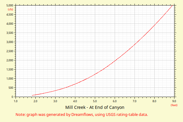
| Height (feet) | .0 | .1 | .2 | .3 | .4 | .5 | .6 | .7 | .8 | .9 |
| 1 | 50 | 63 | 78 | 94 | 111 | |||||
| 2 | 128 | 145 | 164 | 188 | 212 | 236 | 261 | 287 | 315 | 344 |
| 3 | 374 | 405 | 437 | 471 | 505 | 541 | 578 | 616 | 655 | 695 |
| 4 | 737 | 779 | 823 | 868 | 914 | 962 | 1011 | 1064 | 1117 | 1174 |
| 5 | 1234 | 1295 | 1359 | 1427 | 1497 | 1569 | 1644 | 1724 | 1806 | 1889 |
| 6 | 1974 | 2060 | 2148 | 2238 | 2329 | 2422 | 2517 | 2613 | 2710 | 2810 |
| 7 | 2910 | 3013 | 3116 | 3222 | 3329 | 3437 | 3547 | 3659 | 3772 | 3886 |
| 8 | 4002 | 4120 | 4239 | 4359 | 4481 | 4604 | 4729 | 4855 | 4983 | 5112 |
| 9 | 5243 | 5375 | 5509 | 5644 | 5780 | 5918 | 6057 | 6198 | 6340 | 6483 |
| 10 | 6628 | 6775 | 6922 | 7071 | 7222 | 7374 | 7527 | 7681 | 7837 | 7995 |
| 11 | 8154 | 8314 | 8475 | 8638 | 8802 | 8968 | 9134 | 9303 | 9472 | 9643 |
| 12 | 9815 | 9989 | 10164 | 10340 | 10518 | 10696 | 10877 | 11058 | 11241 | 11425 |
| Height (feet) | .0 | .1 | .2 | .3 | .4 | .5 | .6 | .7 | .8 | .9 |
| 13 | 11611 | 11797 | 11985 | 12175 | 12365 | 12557 | 12751 | 12945 | 13141 | 13338 |
| 14 | 13536 | 13736 | 13937 | 14139 | 14343 | 14548 | 14754 | 14961 | 15169 | 15379 |
| 15 | 15590 | 15803 | 16016 | 16231 | 16447 | 16665 | 16883 | 17103 | 17324 | 17547 |
| 16 | 17770 | 17995 | 18221 | 18449 | 18677 | 18907 | 19138 | 19370 | 19604 | 19838 |
| 17 | 20074 | 20311 | 20550 | 20789 | 21030 | 21272 | 21515 | 21760 | 22005 | 22252 |
| 18 | 22500 | 22750 | 23000 | |||||||